Showing posts with label London. Show all posts

Saturday, 7 September 2024

This is not mainly a walking blog - part 2

One of the things about doing a walking challenge – and particularly a walking challenge involving hills - is it does improve your level of fitness, even if, like me, you still come out of it in your early 50s and overweight.

How to retain that level of fitness is the next question – and the answer is clearly to keep walking (no problem, I like a good walk), and to continue to incorporate hills in that walking.

So with that loose plan in mind and no real schedule this is some of the walking I've been doing this summer. 

Early June: I revisited the last bit of the South Downs Way (Alfriston to Eastbourne) with the aunt who wasn't feeling up to the charity walk. Definitely more able to appreciate the views when I wasn't so exhausted. 


9th June I did a very familiar part of the capital ring - Streatham Common through Crystal Palace (another hill) and Grove Park. No photos from that though, it's too familiar.

I did take some nice pictures later in the month while on holiday in Cornwall. We stayed in a place called Cardignan Woods and got to Heligan and the Eden Project and Fowey.


Shortly after that I had an eye operation (all went well and my eyesight is hugely improved) and then was dog sitting. 

4th August I had a very loose plan take the tube to Camden, have a quick look in the market (I enjoy the vibe but also enjoy getting out again, the crowds are crazy at the weekend) then walk up to Archway, take the hill up to to Highgate and the ridge across to Alexandra Palace and back. 

Somehow though after a bit of meandering I found myself at Chalk Farm and decided to head up Haverstock Hill to Hampstead instead. A hill is a hill. 

Past the ponds on Hampstead and a zigzag towards Highgate (I had to use google maps for this bit, I'm not that familiar with Highgate).


Then at Highgate I picked up the parkland walk to Crouch End. This follows an abandoned railway line, and the pictures below are of the old station.


By that time I was quite tired so I picked up a bus to the nearest tube and came home. 

The week after was far less hilly. I started in Poplar and walked up the river Lea from Bow Creek nature reserve. 

My aunt’s response to this picture was that Poplar had changed. well some of it has, and a lot is still changing. In ten years it will be different again.
     
That was a very hot day - we seem to have had the odd really hot day or two this summer, but nothing consistent. Near this spot I found a community garden, a public toilet and a small cafe where they also did bottles of frozen water, which was very welcome. 

and then along the River Lea and up the canal to Stratford where I ended up outside the Abba Experience just as it was turning out. I'd seen it advertised but had no idea where it was. People looked like they'd had a great time. 

I've left some things out - a trip to Box Hill, definitely, a wander around Borough and to Elephant and Castle after meeting friends and taking in some tourist bits (the monument and something called the Southwark Needle that I must have walked past a dozen times and never noticed) a canal walk from Byfleet to Ripley, a river walk from Richmond to Kingston - I've no pictures and these weren't 'big' walks. 

The next proper walk though was Leith Hill last week. I last went up Leith Hill in March when I was 'in training' and took the longer, slower path from Dorking (incidentally I just checked google maps for the date – 9th March - and google thinks I took a ferry to Dorking on that occasion. It occasionally has these blips. It's like a strange parallel universe.)

This time I went from Ockley, which is the steeper side. There is a footpath from the station to Ockley itself,  but you have to know it and my over-reliance on IT sent me down the road. People were very good about pulling around me and slowing down, but I did have to stop a few times or step up on a high bank. Next time I'm going somewhere unfamiliar I'll have to research it better. 

Anyway I got up the hill - quite breathless (I used the route on Fancy Free Walks, which I like because they don't try to make you install an app as so many of the sites do) - stopped for chocolate fridge cake and coffee from the small cafe (it's really just a hatch in the bottom of the tower) and then went up the tower. 


and down again. 


So that was my summer. It's feeling quite autumnal out now but I'm in Cornwall again next week, which will definitely involve some coastal walking. The plan is to get up St Michael's Mount (either the day I arrive or if I check in too late the next day) and then down to Mousehole where I haven’t been since a teenager and have an explore and a cream tea. 

Then I head across to Tintagel (taking the only sensible public transport route and arriving at 6.20 in the afternoon) visit Tintagel next day, do some more walking, and then go down to Truro for the last two days. 

I have some contingency plans around museums and galleries if the heavens open (especially in Truro, where I’ve never been and which looks rich in history) but at the moment the forecast is patchy, which is good enough. I'm never going to be too far from a cafe or a pub if I have to bail out. 

Friday, 30 December 2022

Roof Garden, Canary Wharf


And some pictures taken from the Thames Clipper. 

My second dose of covid never amounted to much and cleared up very quickly - sore throat, coughing and a weak positive on Christmas Day, and negatives daily from Boxing Day, so Wednesday I went to the Courtauld Gallery and then took the clipper through Central London to Canary Wharf, then out to Barking and all the way back to Putney (changing at Canary Wharf again). It was a bit windy and drizzly, but I was fine, and these pictures don't really do justice to the lights - and the hop on-hop off ticket is really handy. 


Saturday, 24 December 2022

Day Three - again

Thursday morning, on a day I was planning to go into the office and pick up the cake for Christmas at lunch time, then meet my brother (down from Runcorn way) and drop the cake at my cousin's ready for Christmas Day, I tested positive for Covid-19. Cue scrambled arrangements over WhatsApp to get that cake and the main (ready 5pm Friday) picked up, divert my brother (my Dad is testing negative so met him elsewhere) and some cough sweets and more lfts dropped. 

It's come in off the back of a severe cold - which feels like a pattern as the first bout came in on the back of a very severe hayfever, for which I took antihistamines. But two incidents isn't enough for a pattern. It's also come in about seven months after the first lot (I was nine months too young for the last booster) which suggests waning immunity to me. 

It's true that last weekend - when I was still testing negative - was a very busy and crowded weekend. I saw a Beatles tribute band in Carshalton on Thursday and did Christmas shopping on Saturday (Tooting, Clapham, Central London) and went up the shard on Sunday and then Trafalgar Square. Everywhere felt emptier than it should be for Christmas in London, except Liberty's and Foyles, which were chaos. Trafalgar Square had mulled wine and celebrating Argentinians (world cup). 

What I mean is, I could have caught it anywhere. 

So now I'm stuck at home again. I did go for a socially distanced walk over the park yesterday, and I ordered contactless pizza because if I'm missing Christmas I'm blowing my usual grocery budget. It was a Napoli - anchovy and capers and tomato sauce and mozzarella - and incredibly (to me deliciously) salty. Mixed olives and Nutella covered strawberries were ordered as well, but I sampled but didn't finish those. They're in the fridge. 

So here I sit. My symptoms so far are a cough (especially when I lay down), mild sore throat, a slight dip in energy levels - and possibly a dip in mood, although it's tricky to know if that's the virus or disappointment about missing Christmas. This is the third weird Christmas - last year my cousin and her son came down with it, and stopped with the ex and the ex's grandparents who all had it too, while we had Christmas at her home without them, which just felt wrong. The year before we were all locked down of course (being in London, I'm afraid my London-centric brain now can't remember if the rest of the country was locked down before Christmas as well or it was just after. I know we weren't as hard up as Leicester though, which seemed to be locked down for months and months after the rest of us were allowed out). 

I'm keeping my fingers crossed for a mild dose - the worst thing last time was it triggered my eczema, which seems to be behaving itself right now, and the exhaustion, which lingered from a month to six weeks I think. 

Anyway it's Christmas Eve, so Merry Christmas, if anyone's reading this, hope you're well and where you need to be, and I should be free by the New Year. 


Sunday, 23 October 2022

Battersea

Somewhere I know I have a picture of Battersea Power Station before the rebuild, which I wanted to add to this post, but I can't find it on 365 or any of my USBs so it's just pictures I took yesterday, of the new development. About a third of the shops are empty, the lift up the chimney and access to the boiler look like they're still being finished, as does the full promenade past and into London, but it's bright, shiny, massive, and will either do phenomenally well (especially this Christmas) or be a huge white elephant because it's launched at the worst possible time (Brexit/Covid/Energy Crisis/Financial Crash/Current Cabinet imploding). It was incredibly busy, huge queues for food, but I didn't see too many people buying actual stuff. I think many of them, like me, were just there to look. 


and then I went to Battersea Park, where the autumn colour is fantastic right now


Saturday, 18 June 2022

Open London Garden Squares Weekend - or is it London Open Garden Squares Weekend?

According to Paul Wood, in a book I must get round to reading, London is a Forest. It's often quite hard to credit this - today, for example, on the top of a bus circumnavigating Elephant and Castle, it wasn't easy to see how something as vital and squishy as human beings manage to live here, let alone foxes and hoverflies and eight million (apparently) trees. 

If you did want convincing though you could do a lot worse than get a weekend pass for London Open Garden Squares Weekend, which is usually held about mid June, and stroll from green space to green space around Bloomsbury or Kensington. 

This time though we started at Charing Cross and the roof of the Coutts building (access was via ballot, as numbers are restricted). This is a container garden, including fruit and flowers, which runs around the top floor. It's an impressively thriving garden - I saw ladybird larvae - the sort where you know if you picked a tomato it would taste really good and not all watery like shop bought ones sometimes do, but it's more remarkable for it's location than the garden itself. As our guide pointed out, you could do this on lots of buildings - why don't we?


St Martins from the top of Coutts

I don't seem to have taken any more photos on the Saturday. I don't know why. We went to Waterloo Gardens and the Phoenix Garden and Bedford and Montague Squares, walked through Woburn Square Garden and Gordon Square (both of which I think are normally open anyway) and round Park Square off Regents Park - which has a tunnel connecting the two halves called 'Nursemaids' Tunnel' as it was built so that those with children could go under the busy road rather than have to attempt to cross it - and up to the Garden at the Royal College of Physicians. What most of these were remarkable for was my having vaguely registered some of them as locked gates or hedges behind cast iron railings without appreciating their size or tallying them up as green space. 

Somehow this lots-of-little-gardens knowledge feels like it adds up to more greenery than the vast swathes of the Royal Parks I'm already aware of. Perhaps not in acreage, but there's an intimacy to them - often it's usually only residents who have access - and a frequency as well, especially if you do as we did and visited them on the basis of proximity rather than any set plan. 

Sunday I was by myself so first went to the Royal Hospital for Neuro Disability, which is relatively close to me in Putney. Apparently the grounds were originally laid out by Capability Brown, but understandably the hospital has other priorities and there's a lot of modern buildings you have to try and filter out to get a flavour of what it must once have been like. There are also sensory gardens, and a terrace with roses, but it all feels a little incoherent. Nothing pulls it together as one garden. 

On the other hand it definitely is a very pleasant space for staff, patients and family to sit and eat lunch or wander while talking. 

The lemon sponge cake was divine as well. 

Then I went into Kensington. First to Earls Court Square, then Barkston Gardens. 


Then after that (passing Bramham Gardens, which were not open - some gardens are only open one day of the weekend, some don't participate, I think it depends on whether they can get volunteers) I went to Courtfield Gardens, which is a Garden of two halves - West and East. 


After that I went to Collingham Gardens, which is particularly charming because the residential buildings around it aren't the other side of the road as with most of these London Squares but back onto it and have steps straight in. 


All these have large grassy areas by the way, and two have children's parks with swings and things. Some have deckchairs. They're proper places for residents to play and rest. That said, it's not quite like a private garden. There are regulations about vacating at dusk or where you can play ball games or how many people you can bring in from outside. I don't know if the residents do some of the gardening - generally the Kensington ones seemed far too well groomed for that to be the case, whereas with the Phoenix Garden the fact it's volunteers and reclaimed materials is clearly the point. 

Next year, assuming it's running, I'd like to focus on Westminster and the City - although I suspect it will be slimmer pickings there. 

Monday, 14 March 2022

River Graveney Walk (part 2)

Somewhere under London Rd/Streatham High Rd (Google and the actual road sign are in dispute which it is at this point) the Norbury Brook becomes the River Graveney. It's a relatively easy thing to find, either coming straight from my last post, in which case it's dead ahead over the road, or from Norbury Station, in which case cross the road and walk up the left hand pavement until you come to it. The river emerges under a slightly arched bridge with two tunnels (despite disappearing under a flat bridge with one) and can be walked for a short stretch along Hermitage Path. 


Looking back towards Streatham High Rd


Hermitage path leads through a small housing estate and if you keep straight ahead and under the railway bridge it will take you to Woodmansterne Rd. Turn right into Sherwood Avenue, which first crosses (invisibly as far as I can see) and then runs parallel to the river. On your left a short way up will be an alley you want to turn down. It leads over the river to Runnymede Crescent. 


Turn right into Runnymede Crescent and continue down the right hand pavement. At the end turn right back into Woodmansterne, then next right into Hawkhurst. What you're essentially doing in this bit is zigzagging: left into Sherwood, walk on for a bit, then left into Helmsdale, right into Woodmansterne, right into Streatham Vale, left into Braeside Rd. The river is fenced off - mostly with gates at all the points you're crossing it, but it can be seen. 

If you look to your left at the end of Braeside Rd as you cross Abercairn Rd, you'll see a yellow barrier more or less where the Graveney is too. It's about to dive underground again though. Or rather, the ground is about to rise.  

Cross Abercairn and walk up Bates Crescent and into Eardley Road Sidings Nature Reserve and take a right along the path (or if you prefer you can turn left and circuit the whole thing). Ahead of you will be the railway these sidings were reclaimed from. The Graveney runs straight under the embankment, but as three distinct railway lines meet in this area the pedestrian has to take a long detour. 

Go back to Abercairn Rd and turn left into it. Turn right at the end into Aberforth Rd, and then left into Carnforth Rd (where the cars can't go anymore, but you can). At the end of  Carnforth Rd turn left into Eardley Rd and under the double railway bridge. 

Turn left into Besley Street, and at the end turn right into Eastwood Street and left into Fallsbrook St. Fallsbrook Street runs straight ahead for a bit and then turns sharp right to follow the Graveney, which is hidden behind the houses. I've explored and there's no way to actually see it along this or the corresponding road on the other side of the river (Rural Way), until you reach the end of the road where it flows under Mitcham Lane.


A plaque on the bridge appears to be a boundary marker - one side LCC (presumably for London County Council) one side SCC, for Surrey County Council, whose headquarters were in Kingston and who were clearly very worried about what might happen to the bridge up on the northern wilds of their domain:


Cross Mitcham Lane - probably best to use the crossing - and turn up Southcroft Rd, which you'll notice slopes steeply down on the left hand side, although you can't see anything behind the large buildings with their concrete front gardens. 

In Swain Close, on the left, there is one corner you can get a glimpse of the river if you're tall, or raise your phone up like I did. Frankly its a sliver, but it's reassurance that it's there. 

Walk along and turn left up Eastbourne Rd. 


And right into Seely Rd. Again you're parallel but cannot see the river. I even wandered into a mews of new builds just before Amen Corner, but the river must be underground at that point as there was nothing. 

At the end of Seely Rd turn left into Mitcham Rd. Just before the railway line turn right into Longley Rd (note the slope down again) and then left just before the church down a footpath to the bridge over the railway line. According to the map the Graveney resurfaces a little further along the railway line - but I suspect it's only visible when it floods. If you look right while crossing the bridge there's quite a lot of undergrowth which may indicate water, but nothing definite. 

Cross the bridge and turn right into Robinson Road. You will pass a few closes on your right, but as with Longley Rd there is no evidence of water until the very last - and then you can only get to it if the carpark gate is open. Again it's a sliver. 

At the end of Robinson Rd there is a kind of weir I've photographed before. 


At this point the Graveney appears to run underground until it emerges alongside the railway line off Wandle Meadow Nature Park. I've tried the roads on the right where it appears to be heading, and mostly hit dead ends of railway line and there is no sign of water. 

The easiest and pleasantest way to continue the walk is to turn left out of Robinson Road and walk straight ahead to Colliers Wood, crossing the road at the Charles Holden Pub and walking straight ahead into the park (pub now on your left, flats on the right). Aim for the top right corner entrance (past the children's playground) into Byegrove Road (running along the left boundary of this park by the way is the Wandle, which the Graveney is about to join. You're currently on what is known as the Wandle Path, a popular route for cyclists, dog walkers and those heading to Plough Lane on match day.) 

Cross Byegrove Road and go down the footpath on the left just as Byegrove turns into Denison Rd. The path will become a road alongside a railway line, then a path again under a railway bridge. Just keep walking. Shortly after the railway bridge a concrete wall on your left indicates the river has re-surfaced. 


If you keep walking you will come to a metal walkway over the river, from which you can see where the Graveney becomes part of the River Wandle. 


(Incidentally after this I went round to Lambeth Cemetery, which is on the other side of the railway line to all those dead ends I mentioned earlier. It's sloped and very damp in the spot nearest the railway track, and there's an absence of graves in the damp spot, so if I had to guess I'd say the river is culverted to cut straight back to the railway from Robinson Rd, and then runs underground alongside it).  

Tuesday, 8 March 2022

River Graveney Walk (Part 1: Norbury Brook)

The Norbury Brook - which becomes the River Graveney downstream, and eventually flows into the Wandle just beyond Colliers Wood - is, as I've said before, an elusive beast. It rises, according to Wikipedia, 'somewhere near Lower Addiscombe Road' but becomes visible from Heaver's Meadow. Anyway, in the absence of any clear idea where it actually runs between those two points, and on the basis that green spaces are a) more pleasant to walk through and b) possibly there because of unstable ground due to a buried waterway, I've designed my own meandering route for the first part.

Unusually for me, I'm also going to make these instructions as clear as possible as I can't see that anyone else has posted a guide to walking this brook, so this is a warning in advance that this will probably be a long, picture-heavy, not especially chatty, post. 

From Addiscombe Tram Stop:

Turn right and walk along the right hand pavement until you reach East India Way. There will be a number of other roads leading off to the right before that, and the park you're heading for runs along the back of these, but those roads end in spiky metal fences rather than gates.

Anyway to walk the length of the park East India Way is best. Pass under the arch and walk straight ahead.

According to Croydon Council website East India Estate (a conservation area over the other side of Lower Addiscombe Road from where you are) is on the site of the former East India Trading Company Military Academy. I'm not sure if this road was also a part of that academy, but it seems likely. Boggle, if you like, at the concept of a private company being allowed to train an army to protect its interests abroad. Friends and shareholders in high places? Or pure Imperialism?  

At the end of East India Way there is a footpath and gate into Addiscombe Railway Park. On the left is the community garden, and if you look back you can see central Croydon, which is casting multiple buildings up to the sky at present. Croydon was heavily bombed during the Second World War (presumably because of the airport and the good train links to London and the Coast) and came back with a lot of concrete 'space age' type buildings that look dated now but must have seemed like the clean, uncluttered future sixty years ago. I think it's trying to pull the same trick again, but although I wish it luck, I'm not sure it's going to work a second time.

Is it just me or does this look unnervingly like a grave? Here lieth the body of Addiscombe Railway. 

You want to walk the full length of the park and come out at Blackhorse Lane tram stop. Climb the steps or ramp up to the bridge over the tram line and turn right. Bear right onto Woodside Green, ignoring Elmers Rd, which is before it. 

At the green itself, with it's war memorial, bear left and then turn left down Dickenson's Lane. There is a path straight ahead at the end which takes you to Brickfield's Meadow. A noticeboard on the right will tell you all about the brick factory which used to be here, which is just as well because I can't remember a word of it beyond those bare facts. 

This is actually a lovely spot, even in the drizzle. Keep walking forwards - a pond should appear on your left. You can go round the pond at the top or down to cross the small and muddy bridge. 


Brickfield's Meadow 

At the top right of the pond (from the end you originally approached it from) and with the pond to your back head through the car parks or stick to Christie Drive to get to Davidson Road. 

Davidson Road runs parallel to roads called Canal Walk and Towpath Way, which sound promising, but if the brook is here it's firmly underground, so you may as well turn right into Davidson Road at the end of Christie Drive, and once at the end of Davidson Road left into Tennison Rd, which will take you over the railway line. On your right is South Norwood Rec, and on your left just a bit further down is Heavers Meadow (it's signposted and just before the Zebra crossing). 

Down this same dead end is also Heavers Farm primary school (I keep wanting to put an apostrophe in both of those, on the basis that surely Heaver must have been a person or people, but history, or at least google, if not forthcoming about who or what Heaver was). 

Internet sources are forthcoming about the fact that Heavers Meadow is a water meadow, which I can confirm from direct observation.


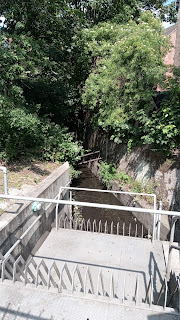
A tarmacked path runs up the left hand side to keep you dry, alongside a metal fence the other side of which the brook will eventually appear, fenced off. 

The reasoning behind culverting these natural streams in London, which has been going on for a good hundred years or more, was to speed water out of an area as fast as possible and prevent flooding - but doesn't always work, can cause problems downstream and often involves deep concrete channels in which water rises very quickly (hence the fence). Some areas are now trying planting and encouraging their local brooks to take a more meandering course to slow them down and create green corridors. If anyone were to try that with this brook a water meadow would seem the place to start it. 


Taken through the fence. Most of the pictures on this section are taken through fences or over walls meant to deter people getting in the river. 

As with the Railway Park, you simply walk to the end of Heavers Meadow until you get to Selhurst Road, where the brook goes underground again. Over the road to your left is Selhurst station.  


This very attractive rondel is outside the station, and made by artyface.

For the next stretch you need to be the other side of the railway line. The easiest way to do that is to go under the railway bridge by Selhurst station and directly right up Edith Rd. You can then turn right into Dagnell Park or walk up a bit further and wait until Eileen Rd (what is the story behind these roads being named Edith and Eileen I wonder? Sisters? Daughters? Or just 'we had to name them something'?) either way you will get to Saxon Rd, where you turn left and then right into Whitehorse Rd. You should be diagonally opposite a small church/chapel. 

Cross Whitehorse Rd but continue along it to Bensham Manor Rd (I've explored the road with the chapel in it and the housing estate and found no sign of the brook at all). 

Turn down the second road on your left, Swain Rd, and walk along the left hand pavement. About halfway down is Treetops Court, and if you turn in there you will find the brook has resurfaced, running between the car park and a row of properties each with it's own small bridge. Here the pedestrian is only protected from it by a wire fence, and a low one of just four wires at that, which seems at odds with how it's fenced off elsewhere, but may be because these are newer builds and as I said, attitudes have changed. Go back to Swain Lane and continue walking down the left hand pavement, and then turn right, and next right again into Ecclesbourne Rd. 


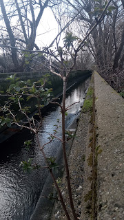
If you're taller than me (and most people are) you may be able to see over the wall halfway down Ecclesbourne behind which the brook is. If not you can do what I did for many of the pictures I took on this walk, which was hold my camera up above my head and tilt it down to snap a picture to look at later. Thus:


I won't post all these. They're all quite similar, although some have a much better feel for how deep that culvert runs (you can see how it would be treacherous) and in others you can see how surprisingly fast the water flows. 

At the end of Ecclesbourne turn left back into Bensham Manor Rd again. A little way down is Bensham Close. If you turn in here and walk to the end (it's not very long) you will come to the brook without any fencing at all. Again, this seems to be because it is a newish development. 


The banks are also thickly planted with some kind of bulb. This will probably be a very nice spot in full spring. 

Retrace your steps to Bensham Manor Rd and turn left at Seneca Rd. If you're a completist, turn left again up Boswell Rd to find another wall hiding the brook, and then retrace your steps to Seneca, walk along Seneca Rd until it becomes Lucerne Rd and you will find another wall almost immediately doing the same thing, again retrace your steps to the corner of Lucerne and Boswell Rd and turn left up Boswell Rd to the Brigstock Rd (I promise these instructions make more sense in situ!). 

This is the main road through Thornton Heath and unmistakable as an outer London high street. If you cross Brigstock Rd (carefully! This is the road where someone beeped his car horn at me because he wanted to park on the bit of pavement where I was standing. He wasn't particularly antagonistic, mind you, he just thought pavements were for parking on and to be fair to him when I looked around it was clear he wasn't the only one.) you'll find Brook Rd straight ahead, but first turn left to walk a little way down Brigstock Rd to find a low wall over the brook. 


Now go back to Brook Rd. The brook itself runs round the back of the houses. You can turn left up Quadrant Rd to get another pic very similar to the one(s) you have and then retrace your steps, or just keep straight ahead as Brook Rd turns into Carew Rd and arrives at Thornton Heath recreation ground. 

There is a community garden on your right just inside the gate, with a fine showing of daffodils right now, but you want to keep left along the path until it meets the brook (again behind a fence) on your left hand side. It you keep walking you will pass the other park entrance with it's bridges over the brook and eventually hit the fences of people's back gardens at the far end. Turn round and go back to the entrance with the bridges and cross the brook. 

Turn right along Bridport Rd and right again into Braemar Avenue. Again there is a barrier, this time about a third of the way down the road, but you can see the brook (or at least the channel and lush growth) around it. 


Incidentally if you've done all this, I estimate you've done at least six miles walking (I'd done more than eight, what with the diversions). We'll go just a little further to Norbury, and you can get a coffee or bail out until next time.

Continue down Braemar and turn left, then left again into Strathayre Avenue. Just before the road on the right (Dalmeny Rd) the brook runs diagonally under Strathayre, but it appears to be behind people's gardens or front hedges and there's only so nosy I'm prepared to be. 

Anyway you want to go down Dalmeny. Walk along until you get to Ederline Avenue on the right. Along Ederline is a metal fence, and on the other side of the road a metal fence and gate. Brook still there, running along behind the terraces. Sadly despite a strongly worded notice from Croydon council basically saying 'this is not a dumping ground and we will fine you' one side has been turned into a dumping ground at this present time. Continue along Ederline and turn left into Norbury Crescent. 

Turn right at Manor Farm Rd and under the railway line. You can read about the Manor (and later the farm) on Hidden London here. There is also an antique postcard of the farm for sale online, but from the picture it just looks like a farm. Big house, field, pond. 

There is a short curved stretch of the brook on your left as you come out from under the bridge (picture again taken through the fence). 


Turn left out of Manor Farm Road into Norbury Avenue. Continue along the right hand pavement until you come to a footpath and allotments, Turn down the footpath, which runs over the brook and at the end of the path turn left through Norbury Park.  

According to the map there's water diagonally across Norbury Park to the row of yellowish brick buildings opposite - actually there's no water but just a lot of quagginess underfoot (maybe it floods sometimes?) anyway aim for those yellow buildings and you'll find the brook surfaces again in the usual concrete channel. Walk along with the brook on your right, and continue straight ahead through the car park when it ends. 


I want to say you're now on Norbury High Street, but apparently it's not called that. Left for the train station, either direction for pubs, cafes, restaurants, buses. Straight ahead on the other side of the road the brook becomes the River Graveney, which I'll come back to in part 2.