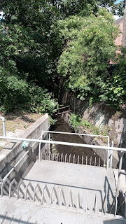
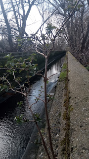
If you look to your left at the end of Braeside Rd as you cross Abercairn Rd, you'll see a yellow barrier more or less where the Graveney is too. It's about to dive underground again though. Or rather, the ground is about to rise.
Cross Abercairn and walk up Bates Crescent and into Eardley Road Sidings Nature Reserve and take a right along the path (or if you prefer you can turn left and circuit the whole thing). Ahead of you will be the railway these sidings were reclaimed from. The Graveney runs straight under the embankment, but as three distinct railway lines meet in this area the pedestrian has to take a long detour.
Go back to Abercairn Rd and turn left into it. Turn right at the end into Aberforth Rd, and then left into Carnforth Rd (where the cars can't go anymore, but you can). At the end of Carnforth Rd turn left into Eardley Rd and under the double railway bridge.
Turn left into Besley Street, and at the end turn right into Eastwood Street and left into Fallsbrook St. Fallsbrook Street runs straight ahead for a bit and then turns sharp right to follow the Graveney, which is hidden behind the houses. I've explored and there's no way to actually see it along this or the corresponding road on the other side of the river (Rural Way), until you reach the end of the road where it flows under Mitcham Lane.
A plaque on the bridge appears to be a boundary marker - one side LCC (presumably for London County Council) one side SCC, for Surrey County Council, whose headquarters were in Kingston and who were clearly very worried about what might happen to the bridge up on the northern wilds of their domain:
Cross Mitcham Lane - probably best to use the crossing - and turn up Southcroft Rd, which you'll notice slopes steeply down on the left hand side, although you can't see anything behind the large buildings with their concrete front gardens.
In Swain Close, on the left, there is one corner you can get a glimpse of the river if you're tall, or raise your phone up like I did. Frankly its a sliver, but it's reassurance that it's there.
Walk along and turn left up Eastbourne Rd.
And right into Seely Rd. Again you're parallel but cannot see the river. I even wandered into a mews of new builds just before Amen Corner, but the river must be underground at that point as there was nothing.
At the end of Seely Rd turn left into Mitcham Rd. Just before the railway line turn right into Longley Rd (note the slope down again) and then left just before the church down a footpath to the bridge over the railway line. According to the map the Graveney resurfaces a little further along the railway line - but I suspect it's only visible when it floods. If you look right while crossing the bridge there's quite a lot of undergrowth which may indicate water, but nothing definite.
Cross the bridge and turn right into Robinson Road. You will pass a few closes on your right, but as with Longley Rd there is no evidence of water until the very last - and then you can only get to it if the carpark gate is open. Again it's a sliver.
At the end of Robinson Rd there is a kind of weir I've photographed before.
At this point the Graveney appears to run underground until it emerges alongside the railway line off Wandle Meadow Nature Park. I've tried the roads on the right where it appears to be heading, and mostly hit dead ends of railway line and there is no sign of water.
The easiest and pleasantest way to continue the walk is to turn left out of Robinson Road and walk straight ahead to Colliers Wood, crossing the road at the Charles Holden Pub and walking straight ahead into the park (pub now on your left, flats on the right). Aim for the top right corner entrance (past the children's playground) into Byegrove Road (running along the left boundary of this park by the way is the Wandle, which the Graveney is about to join. You're currently on what is known as the Wandle Path, a popular route for cyclists, dog walkers and those heading to Plough Lane on match day.)
Cross Byegrove Road and go down the footpath on the left just as Byegrove turns into Denison Rd. The path will become a road alongside a railway line, then a path again under a railway bridge. Just keep walking. Shortly after the railway bridge a concrete wall on your left indicates the river has re-surfaced.
If you keep walking you will come to a metal walkway over the river, from which you can see where the Graveney becomes part of the River Wandle.
(Incidentally after this I went round to Lambeth Cemetery, which is on the other side of the railway line to all those dead ends I mentioned earlier. It's sloped and very damp in the spot nearest the railway track, and there's an absence of graves in the damp spot, so if I had to guess I'd say the river is culverted to cut straight back to the railway from Robinson Rd, and then runs underground alongside it).


No comments:
Post a Comment