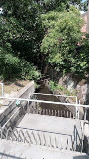
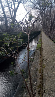
The Norbury Brook - which becomes the River Graveney downstream, and eventually flows into the Wandle just beyond Colliers Wood - is, as I've said before, an elusive beast. It rises, according to Wikipedia, 'somewhere near Lower Addiscombe Road' but becomes visible from Heaver's Meadow. Anyway, in the absence of any clear idea where it actually runs between those two points, and on the basis that green spaces are a) more pleasant to walk through and b) possibly there because of unstable ground due to a buried waterway, I've designed my own meandering route for the first part.
Unusually for me, I'm also going to make these instructions as clear as possible as I can't see that anyone else has posted a guide to walking this brook, so this is a warning in advance that this will probably be a long, picture-heavy, not especially chatty, post.
From Addiscombe Tram Stop:
Turn right and walk along the right hand pavement until you reach East India Way. There will be a number of other roads leading off to the right before that, and the park you're heading for runs along the back of these, but those roads end in spiky metal fences rather than gates.
Anyway to walk the length of the park East India Way is best. Pass under the arch and walk straight ahead.
According to Croydon Council website East India Estate (a conservation area over the other side of Lower Addiscombe Road from where you are) is on the site of the former East India Trading Company Military Academy. I'm not sure if this road was also a part of that academy, but it seems likely. Boggle, if you like, at the concept of a private company being allowed to train an army to protect its interests abroad. Friends and shareholders in high places? Or pure Imperialism?
At the end of East India Way there is a footpath and gate into Addiscombe Railway Park. On the left is the community garden, and if you look back you can see central Croydon, which is casting multiple buildings up to the sky at present. Croydon was heavily bombed during the Second World War (presumably because of the airport and the good train links to London and the Coast) and came back with a lot of concrete 'space age' type buildings that look dated now but must have seemed like the clean, uncluttered future sixty years ago. I think it's trying to pull the same trick again, but although I wish it luck, I'm not sure it's going to work a second time.
Is it just me or does this look unnervingly like a grave? Here lieth the body of Addiscombe Railway.
You want to walk the full length of the park and come out at Blackhorse Lane tram stop. Climb the steps or ramp up to the bridge over the tram line and turn right. Bear right onto Woodside Green, ignoring Elmers Rd, which is before it.
At the green itself, with it's war memorial, bear left and then turn left down Dickenson's Lane. There is a path straight ahead at the end which takes you to Brickfield's Meadow. A noticeboard on the right will tell you all about the brick factory which used to be here, which is just as well because I can't remember a word of it beyond those bare facts.
This is actually a lovely spot, even in the drizzle. Keep walking forwards - a pond should appear on your left. You can go round the pond at the top or down to cross the small and muddy bridge.
Brickfield's Meadow
At the top right of the pond (from the end you originally approached it from) and with the pond to your back head through the car parks or stick to Christie Drive to get to Davidson Road.
Davidson Road runs parallel to roads called Canal Walk and Towpath Way, which sound promising, but if the brook is here it's firmly underground, so you may as well turn right into Davidson Road at the end of Christie Drive, and once at the end of Davidson Road left into Tennison Rd, which will take you over the railway line. On your right is South Norwood Rec, and on your left just a bit further down is Heavers Meadow (it's signposted and just before the Zebra crossing).
Down this same dead end is also Heavers Farm primary school (I keep wanting to put an apostrophe in both of those, on the basis that surely Heaver must have been a person or people, but history, or at least google, if not forthcoming about who or what Heaver was).
Internet sources are forthcoming about the fact that Heavers Meadow is a water meadow, which I can confirm from direct observation.
A tarmacked path runs up the left hand side to keep you dry, alongside a metal fence the other side of which the brook will eventually appear, fenced off.
The reasoning behind culverting these natural streams in London, which has been going on for a good hundred years or more, was to speed water out of an area as fast as possible and prevent flooding - but doesn't always work, can cause problems downstream and often involves deep concrete channels in which water rises very quickly (hence the fence). Some areas are now trying planting and encouraging their local brooks to take a more meandering course to slow them down and create green corridors. If anyone were to try that with this brook a water meadow would seem the place to start it.
Taken through the fence. Most of the pictures on this section are taken through fences or over walls meant to deter people getting in the river.
As with the Railway Park, you simply walk to the end of Heavers Meadow until you get to Selhurst Road, where the brook goes underground again. Over the road to your left is Selhurst station.
This very attractive rondel is outside the station, and made by
artyface.
For the next stretch you need to be the other side of the railway line. The easiest way to do that is to go under the railway bridge by Selhurst station and directly right up Edith Rd. You can then turn right into Dagnell Park or walk up a bit further and wait until Eileen Rd (what is the story behind these roads being named Edith and Eileen I wonder? Sisters? Daughters? Or just 'we had to name them something'?) either way you will get to Saxon Rd, where you turn left and then right into Whitehorse Rd. You should be diagonally opposite a small church/chapel.
Cross Whitehorse Rd but continue along it to Bensham Manor Rd (I've explored the road with the chapel in it and the housing estate and found no sign of the brook at all).
Turn down the second road on your left, Swain Rd, and walk along the left hand pavement. About halfway down is Treetops Court, and if you turn in there you will find the brook has resurfaced, running between the car park and a row of properties each with it's own small bridge. Here the pedestrian is only protected from it by a wire fence, and a low one of just four wires at that, which seems at odds with how it's fenced off elsewhere, but may be because these are newer builds and as I said, attitudes have changed. Go back to Swain Lane and continue walking down the left hand pavement, and then turn right, and next right again into Ecclesbourne Rd.
If you're taller than me (and most people are) you may be able to see over the wall halfway down Ecclesbourne behind which the brook is. If not you can do what I did for many of the pictures I took on this walk, which was hold my camera up above my head and tilt it down to snap a picture to look at later. Thus:
I won't post all these. They're all quite similar, although some have a much better feel for how deep that culvert runs (you can see how it would be treacherous) and in others you can see how surprisingly fast the water flows.
At the end of Ecclesbourne turn left back into Bensham Manor Rd again. A little way down is Bensham Close. If you turn in here and walk to the end (it's not very long) you will come to the brook without any fencing at all. Again, this seems to be because it is a newish development.
The banks are also thickly planted with some kind of bulb. This will probably be a very nice spot in full spring.
Retrace your steps to Bensham Manor Rd and turn left at Seneca Rd. If you're a completist, turn left again up Boswell Rd to find another wall hiding the brook, and then retrace your steps to Seneca, walk along Seneca Rd until it becomes Lucerne Rd and you will find another wall almost immediately doing the same thing, again retrace your steps to the corner of Lucerne and Boswell Rd and turn left up Boswell Rd to the Brigstock Rd (I promise these instructions make more sense in situ!).
This is the main road through Thornton Heath and unmistakable as an outer London high street. If you cross Brigstock Rd (carefully! This is the road where someone beeped his car horn at me because he wanted to park on the bit of pavement where I was standing. He wasn't particularly antagonistic, mind you, he just thought pavements were for parking on and to be fair to him when I looked around it was clear he wasn't the only one.) you'll find Brook Rd straight ahead, but first turn left to walk a little way down Brigstock Rd to find a low wall over the brook.
Now go back to Brook Rd. The brook itself runs round the back of the houses. You can turn left up Quadrant Rd to get another pic very similar to the one(s) you have and then retrace your steps, or just keep straight ahead as Brook Rd turns into Carew Rd and arrives at Thornton Heath recreation ground.
There is a community garden on your right just inside the gate, with a fine showing of daffodils right now, but you want to keep left along the path until it meets the brook (again behind a fence) on your left hand side. It you keep walking you will pass the other park entrance with it's bridges over the brook and eventually hit the fences of people's back gardens at the far end. Turn round and go back to the entrance with the bridges and cross the brook.
Turn right along Bridport Rd and right again into Braemar Avenue. Again there is a barrier, this time about a third of the way down the road, but you can see the brook (or at least the channel and lush growth) around it.
Incidentally if you've done all this, I estimate you've done at least six miles walking (I'd done more than eight, what with the diversions). We'll go just a little further to Norbury, and you can get a coffee or bail out until next time.
Continue down Braemar and turn left, then left again into Strathayre Avenue. Just before the road on the right (Dalmeny Rd) the brook runs diagonally under Strathayre, but it appears to be behind people's gardens or front hedges and there's only so nosy I'm prepared to be.
Anyway you want to go down Dalmeny. Walk along until you get to Ederline Avenue on the right. Along Ederline is a metal fence, and on the other side of the road a metal fence and gate. Brook still there, running along behind the terraces. Sadly despite a strongly worded notice from Croydon council basically saying 'this is not a dumping ground and we will fine you' one side has been turned into a dumping ground at this present time. Continue along Ederline and turn left into Norbury Crescent.
Turn right at Manor Farm Rd and under the railway line. You can read about the Manor (and later the farm) on Hidden London
here. There is also an antique postcard of the farm for sale online, but from the picture it just looks like a farm. Big house, field, pond.
There is a short curved stretch of the brook on your left as you come out from under the bridge (picture again taken through the fence).
Turn left out of Manor Farm Road into Norbury Avenue. Continue along the right hand pavement until you come to a footpath and allotments, Turn down the footpath, which runs over the brook and at the end of the path turn left through Norbury Park.
According to the map there's water diagonally across Norbury Park to the row of yellowish brick buildings opposite - actually there's no water but just a lot of quagginess underfoot (maybe it floods sometimes?) anyway aim for those yellow buildings and you'll find the brook surfaces again in the usual concrete channel. Walk along with the brook on your right, and continue straight ahead through the car park when it ends.
I want to say you're now on Norbury High Street, but apparently it's not called that. Left for the train station, either direction for pubs, cafes, restaurants, buses. Straight ahead on the other side of the road the brook becomes the River Graveney, which I'll come back to in part 2.